
Jomblang is one of hundreds of cave complex in Gunungkidul that becomes well known because of its uniqueness. In 2011, it is used as the object of a program called Amazing Race America. Located on the range of karst hills in the southern coastal spread along Gombong, Central Java up to karst area in Sewu Mountain, Pacitan, West Java, this vertical cave has collapse doline. It was constructed from a geological process when the land and its vegetation vanished into the bowel of the earth thousand years ago. The ruins formed a sinkhole, which in Javanese language was called sumuran or luweng. As a result, the cave which has 50 meter diameter was later named Luweng Jomblang.

To enter Jomblang cave, we need to master single rope technique (SRT). Everyone who wish to do caving in this place should use special equipments based on the caving safety standard in a vertical cave and should also be accompanied by the experienced caving trainers. Together with the cavers from Jomblang Resort, we tried to do caving in this exotic cave. After wearing coverall, boot, helmet, and headlamp, a trainer set SRT set on our body while explaining the name of each tool and its function. The single rope technique equipments consisted of seat harness, chest harness, ascender / croll, auto descender, footloop, jammer, carabiner, long cowstail, and short cowstail.
An adventure to the deep part of the earth was soon started by leaving the basecamp to get to the edge of the cave as the track. There were some tracks in Jomblang cave with various heights, from 40 up to 80 meters. Since this was the very first time for us to do vertical caving, the shortest track, known as the VIP one, was chosen. The first 15 meter from the VIP terrace was a slope that was possibly stepped, and we continued to go down on a 20 meter rope to get to the bottom of the cave. The feeling of scared and nervous when we hung in the air was suddenly disappear when we stepped our feet on the ground.

Surprisingly, the view in front of us was awesome. When we were above, we could only see barren region with hardwood and when we were hanging on the rope to get to the bottom, we could only see karst, but in the bowl of Jomblang cave we could really see the green view of fertile and dense vegetation. Various kinds of moss, fern, bush, and big trees densely grew. A forest with different vegetation from the land above it was usually called ancient forest. Since the geological process of the land happening in the past, those vegetations were continuously growing up to now.
Luweng Grubug, a Visible Heavenly Light

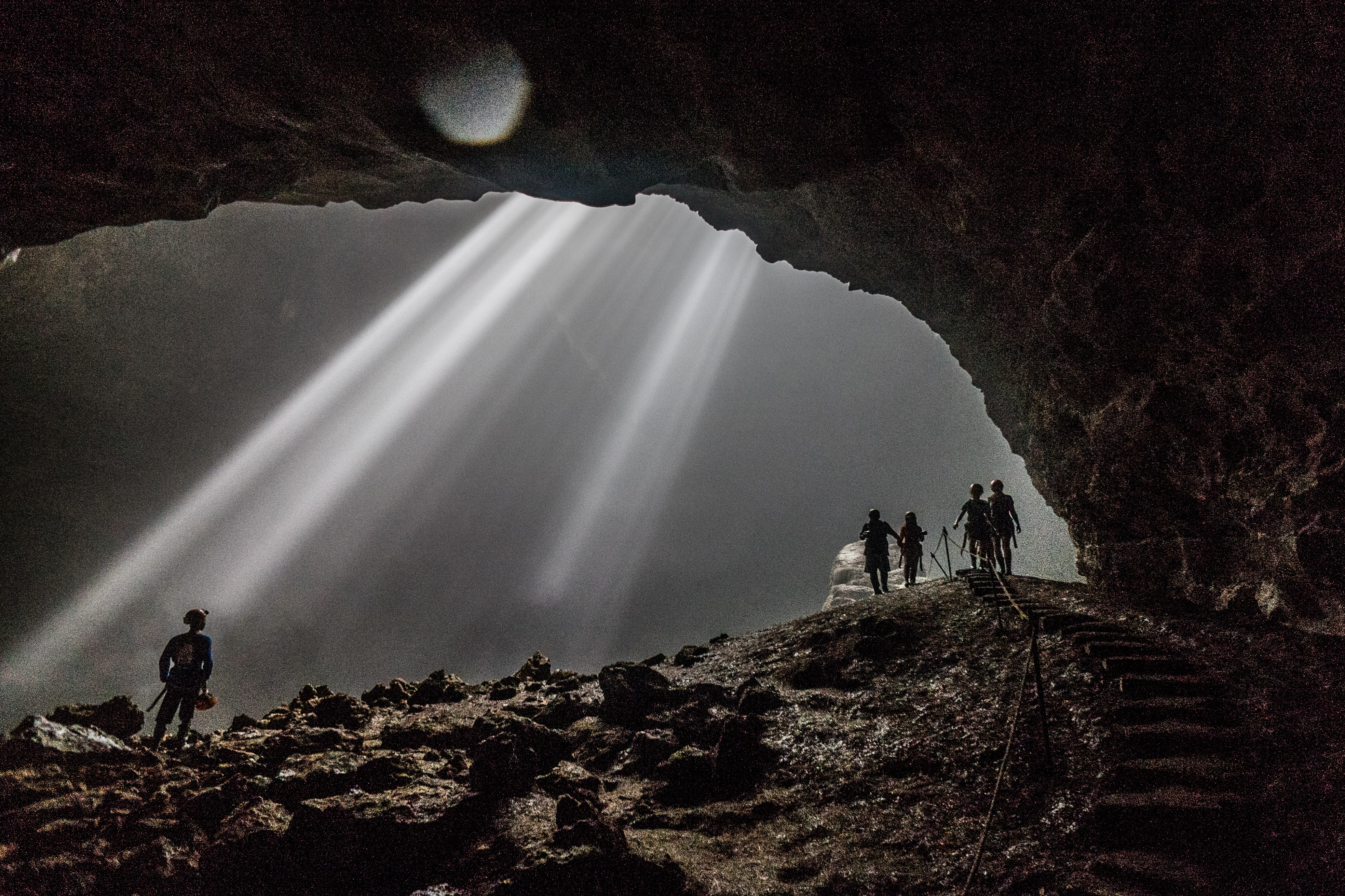
The cave adventure we did was not only stopped at Jomblang. We still continued our journey to Luweng Grubug by entering an entrance, which was an extra large edge of a cave. Jomblang and Grubug were connected by an alley with 300 meters length. Many beautiful ornaments decorated this alley, such as crystal, stalactite, and stalagmite. Walking for a while, we heard thundering sound from the river stream and saw light in the dark. We curiously fastened our steps to see what was going on.

Wonderful scenery, which was really fascinating, spread in front of us. An underground river which still had the same system as Kalisuci flew quickly. The sun light that got in through Laweng Grubug formed a 90 meter light pillar and shone the flowstone in the dark cave. The water drops also made it become a more perfect view. At that time, we really couldn't say anything, but only feeling of amazed and surprised seeing something called light from heaven directly.
Notes:
The best time to enjoy the beauty of Grubug cave is at 10a.m to 12a.m when the sun shines above our head, so that we can see the more beautiful heavenly light.
Anyone who wants to get into Jomblang cave must be equipped with tools which have safety standard for vertical caving and accompanied by well-experienced caver or trainer.
The maximum quotas to get into Jomblang cave are 25 people for the reason of ecosystem stability and the cave condition.

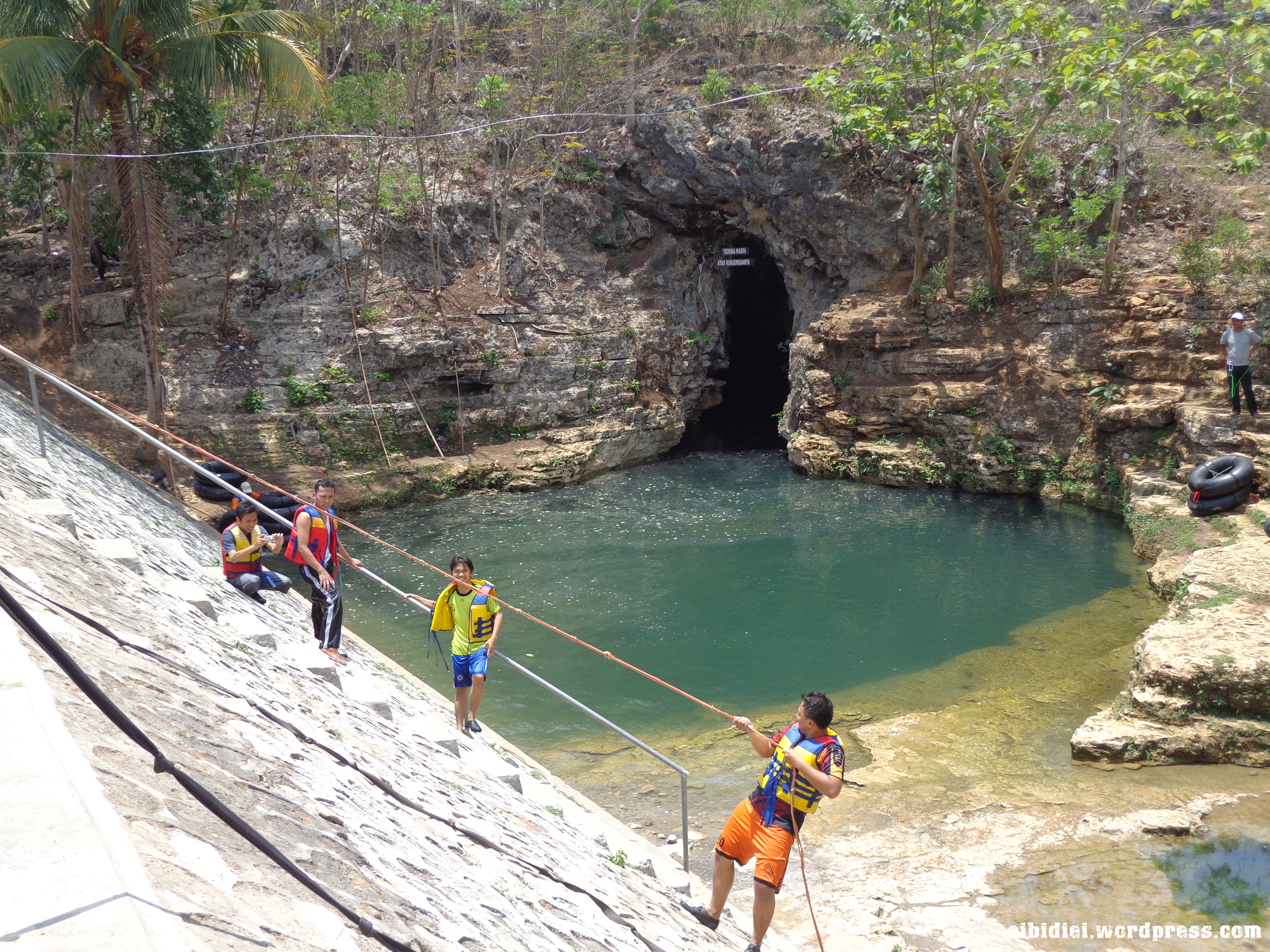
Wading across a river using boat is something common, but if the river is located inside a cave, of course it will be an enjoyable yet challenging experience. Pindul is a cave that becomes part of the group of seven caves with underground river flowing inside. It is located in a village named Bejiharjo, Karangmojo and it offers the real sensation of adventure. For about 45 to 60 minutes, visitors will be invited to go along the river in the darkness of the bowels of the earth with 300 meters length using lifebelt. This is an activity combining body rafting and caving, and later called cave tubing.

No special preparation needed to do cave tubing in Pindul cave. We only need lifebelt, life vest, and headlamp, and those equipments have been provided by the organizer. The still water flow makes it save for everyone, not only adults but also children. The best time to do cave tubing is in the morning at about 9 or 10a.m since the water won't be too cold. Furthermore, if the weather is clear, at that time we may see the light from heaven which is actually the sunlight from above that goes through the big hole on the top of the cave.

While enjoying the smooth wipes on the cold water on our skin in the middle of the cave with less light, the guide told a story of the name Pindul. Based on the legend believed by the indigenous people and passed on orally from generation to the other, the name of Pindul cave and the other caves in Bejiharjo could not be separated from the story of Joko Singlulung's journey to find his father. After exploring the dense forests, mountains, and rivers, Joko Singlulung got into the caves in Bejiharjo. When he got into one of the cave, he bent the rock, so that the place was named Pindul as the short form of pipi gebendul in Javanese language.

Besides telling us about the legend of the name of Pindul cave, the guide also told us about some pretty ornament that we find in the activity, such as crystal, moonmilk, stalactites, and stalagmites. A huge pillar formed from the join process between the stalactite and stalagmite which were thousands years old will greet in front of us. On some parts of the top of the cave, we could see natural picture as formation of bats living there. Meanwhile, in the middle of the cave was a place resembles wide pool where visitors usually take a rest, swim, and jump from above. When we was still enjoying the beautiful ornament while listening to the sound of the baths and the water, it turned out that the cave tubing was over since we had arrived at the end of the cave. We could also see Banyumoto barrage, which was build in the Dutch colonization era, with karst as the background.

 Timang Beach is located in anggolo, Purwodadi, Tepus, Gunung kidul, Yogyakarta. Same locatin with Jogan Kulon Beach. Like another beach in gunung Kidul, Yogyakarta. This beach has beautiful white sand in the left and right side of timang beach thare are cliff that overgrown with Pandanus odorifer that make the cliff look green and beautiful.
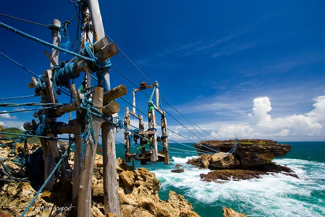
in left side cliff of Timang Beach there are beautiful place for just to sit and have a look the beach and the beautiful view of another beach that can be seen from here. from this place you can see sunset (if you come in the afternoon), the orange sun will sink on the sea. Exquisite afternoon view that will make your photo look awesome and incredibly beautiful.And the best thing that make Timang Beach very special from another beach in Gunung Kidul is there is Gondola that connecting main island to islet that located not far from main Island. this Gondola usually used by local residents to cross to islet to look for Lobster that live in there.

In that right side of Timang Beach you will see sunrise (if you come in the morning) that appers from the mountains, the orange shine will give you warmth. And the best thing in right side of Timang Beach is the gondola that can look from left side of timang beach. in here you can feel ride the traditionals gondola that made by civil residents. there are no modern thing in gondola, everything that made this gondola is traditionals. when you come to islet you can see main island and feel how hard to find lobster in here.

there are no recomended time to go here, both morning and afternoon this beach will greet you and give you the best that she has. you will satisfied with Timang Beach.
Timang Beach is categorized hiddden because only local residents of Yogyakarta or people who have family in Yogyakarta that come here. Rare tourist from internationals come here. so come here and feel Timang Beach by yourself.
Timang Beach is categorized hiddden because only local residents of Yogyakarta or people who have family in Yogyakarta that come here. Rare tourist from internationals come here. so come here and feel Timang Beach by yourself.
Gong Cave
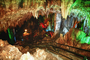
Gong Cave has stalagtite and stalagmite that is said become the beautiful one in South-east Asian. It has about 256 m depth, beside that it also has 5 polls; Rogo Pool, Panguripan Pool, Jiwo Pool, Kamulyan Pool, and Ralung Nisto Pool, which have magical value to heal disease. The beauty of stalagmite and stalagtite is hardly make surprise immortalized by Selo Cengger Bumi named, Cello Giri, Selo Citro Cipto Agung, Cello Pakuan Bomo, Cello Adi Citro Buwono, Cello Bantaran Angin and Cello Susuh Angin.

On certain days every Friday, there is a sound of traditional music called "Jaranan" gong (traditional gong) is the instrument which sound hardest than others. Up to now, sometimes its sound still can be heard, that is why this cave is about 256 meters underground, has 12 rooms, 7 springs and one natural bath.

This cave is located about 30 km west of Pacitan precisely in Bomo village, Punung district and it is easily reach with all types of vehicle about 45 minutes. This area also available some facilities, such as; souvenir shops, restaurants, parking area, Mosque, etc.
On certain days every Friday, there is a sound of traditional music called "Jaranan" gong (traditional gong) is the instrument which sound hardest than others. Up to now, sometimes its sound still can be heard, that is why this cave is about 256 meters underground, has 12 rooms, 7 springs and one natural bath.
This cave is located about 30 km west of Pacitan precisely in Bomo village, Punung district and it is easily reach with all types of vehicle about 45 minutes. This area also available some facilities, such as; souvenir shops, restaurants, parking area, Mosque, etc.


Klayar Beach is resides in Donorojo district, Pacitan Regency. It is about 35 km towards west Pacitan city. It can reach about 60 minutes from the city. Many rockies like spink in Mesir. Klayar Beach with its dune has a distinctive feature from another. Its waves dashed against the rock spourting from the hole make sound like a bamboo flute. The springkling of waves rush to beach and out through the hole spurting about 7 meters high and has a sound like blowing bamboo flute.
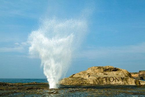
This white sandy beach has an idiosyncrasy that is the flute sea. It is once in a while whistle among reef gap and blast waved. It has white sand and the water is blue which enjoyable to be visited. Despitefully there is also a real natural water fountain. This water fountain “Air Mancur” happened because the wave pressure the air sea which hit bank hollow rock. Water fountain, which can reach of 10 metre height yield drizzle and seawater dew that believed has special quality as ageless drug.


Ijen Crater / Kawah Ijen - Banyuwangi
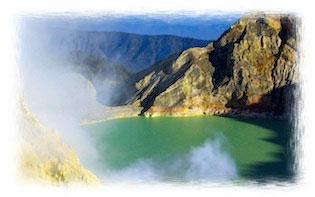
Ijen Crater is the biggest crater lake in Java. The sulfur crater lake lies between a natural dams of deeply etched rock. It is 200 meters deep and contains about 36million cubic meters of steaming acid water, shrouded in a smelling swirling sulfur cloud. Inside the crater the different color and size of stones are found. Indeed the crater of Ijen is beautiful garden of stone as well.
The view of sulfur miners who climb and go down to the crater is also amazing. A man puts about 10 kg of yellowish stone in to his basket, before he descends the mountain slope to sell his load, carrying the same basket, going in the same direction, digging the same mineral. It is the natural picture that can be seen everyday.
Ijen Plateau lies in the centre of Ijen-Merapi Malang Reserve, which extends over much of the mountainous region directly west of Banyuwangi and borders on the Baluran National Park in the northeast. As at Mt. Bromo, the caldera is best viewed from the air. Fortunately, almost all commercial flights operating between Denpasar - Surabaya, Yogyakarta or Jakarta usually fly, if not directly over, then close by Ijen plateau, where the seemingly luminous blue/green crater lake forms an unmistakable landmark. It is beautiful scenery and located about 32 km to the north west of Banyuwangi.

The principal attraction at Ijen is the large Crater Lake that has much sulfur, which lies hidden between sheer walls of deeply furrowed rock at more than 200 meters. The Ijen crater itself lies at approximately 2,300 meters above sea level. It forms a twin volcano with the now extinct Mount Merapi. The enormous Crater Lake, which is 200 meters deep and covers an area of more than meters, a million square meters, contains about 36 million cubic meters of steaming, acid water.
Ijen crater shows a special type of volcanic feature common to Indonesia, about 1 kilometer in diameter and 175 meters deep. The floor is covered completely by a warm lake, milky blue green in colours held back by a dam built many years ago by the Dutch, in order to keep the hot, mineral laden water from raining the crop lands below.

The crater can be reached from either the east or the west by any kinds of vehicles, but the second part of the trip covers distance 3 km on foot (jungle track). However, the latter is more popular approach, since the climb from the road's end to the edge of the lake is only one and a half hours. And a walk around the lake takes a full day.
The temperature drops at night, near the crater rim it can fall to about 5° Celsius. The road ends at Jampit, where very basic shelter is available. It is also possible to sleep in the old vulcanology station further up the hill, now used by sulfur collectors, but permission must be obtained in advance.

The sulfur is transported entirely on foot. In the past, horses were used but they were found to be less practical on the hazardous terrain. Today, the mine yields nine to twelve tons of sulfur per day.
Men carry individual loads of up to 70 kg, often barefooted, up to the rim of crater and then 17 km down the mountainside to a factory near Banyuwangi. The porters are paid by weight. The most important advice if you are traveling to Ijen is: "If you lose your way, just look out for the sulfur trail". The meaning was clear, since a continuous flow of two ways traffic, carrying the sulfur down the mountainside from the lake and trudging up again to re-load, had left a yellow trail on the well-worn path. The best time for seeing Ijen Crater is at 8 to 9 am.
Ijen Plateau lies in the centre of Ijen-Merapi Malang Reserve, which extends over much of the mountainous region directly west of Banyuwangi and borders on the Baluran National Park in the northeast. As at Mt. Bromo, the caldera is best viewed from the air. Fortunately, almost all commercial flights operating between Denpasar - Surabaya, Yogyakarta or Jakarta usually fly, if not directly over, then close by Ijen plateau, where the seemingly luminous blue/green crater lake forms an unmistakable landmark. It is beautiful scenery and located about 32 km to the north west of Banyuwangi.
The principal attraction at Ijen is the large Crater Lake that has much sulfur, which lies hidden between sheer walls of deeply furrowed rock at more than 200 meters. The Ijen crater itself lies at approximately 2,300 meters above sea level. It forms a twin volcano with the now extinct Mount Merapi. The enormous Crater Lake, which is 200 meters deep and covers an area of more than meters, a million square meters, contains about 36 million cubic meters of steaming, acid water.
Ijen crater shows a special type of volcanic feature common to Indonesia, about 1 kilometer in diameter and 175 meters deep. The floor is covered completely by a warm lake, milky blue green in colours held back by a dam built many years ago by the Dutch, in order to keep the hot, mineral laden water from raining the crop lands below.
The crater can be reached from either the east or the west by any kinds of vehicles, but the second part of the trip covers distance 3 km on foot (jungle track). However, the latter is more popular approach, since the climb from the road's end to the edge of the lake is only one and a half hours. And a walk around the lake takes a full day.
The temperature drops at night, near the crater rim it can fall to about 5° Celsius. The road ends at Jampit, where very basic shelter is available. It is also possible to sleep in the old vulcanology station further up the hill, now used by sulfur collectors, but permission must be obtained in advance.
The sulfur is transported entirely on foot. In the past, horses were used but they were found to be less practical on the hazardous terrain. Today, the mine yields nine to twelve tons of sulfur per day.
Men carry individual loads of up to 70 kg, often barefooted, up to the rim of crater and then 17 km down the mountainside to a factory near Banyuwangi. The porters are paid by weight. The most important advice if you are traveling to Ijen is: "If you lose your way, just look out for the sulfur trail". The meaning was clear, since a continuous flow of two ways traffic, carrying the sulfur down the mountainside from the lake and trudging up again to re-load, had left a yellow trail on the well-worn path. The best time for seeing Ijen Crater is at 8 to 9 am.

Parangtritis Beach
One of the attractive beaches near Yogyakarta is Parangtritis. It is located about 27 km. from Yogyakarta, Parangtritis may be reached in two ways, through Kretek Village or the longer one but more well - established road through Imogiri and Siluk Village. Parangtritis Beach is a lovely beach with many impressing phenomena, naturally and supra naturally. The waves regularly bring in new wood and bamboo, washing ashore from another nearby beach probably. Some wood is picked and taken away by locals to be used for their own house. Parangtritis is an enchanting sloping beach combined with rocky hills, dunes, and a white sandy beach. Besides being famous as a recreational spot. Parangtritis is also a sacred place. Many people come to the beach to do meditation. Up to now, this area is remaining functioned as the place to perform the traditional ceremony called labuhan. Many hotels and restaurants are available for sunbathe lovers.

It is said that the name of Parangtritis is expresses a natural phenomenon. From the wall of one of the hills drops off water containing calcium continuously dripped down and finally formed a pool with very clear water in it. Sri Sultan Hamengku Buwono Vll found and took care of it. The pool is now used as the bathing pool of Parangtritis swimming pool. Meanwhile, the sunset at any point of Parangtritis beach brings a touch of wonderful and amazing as well. The magical atmosphere of the rough waves appears to as all hearts into disposing of all bustles and lead into deep musing.


Blogroll
Popular posts
-
Jomblang is one of hundreds of cave complex in Gunungkidul that becomes well known because of its uniqueness. In 2011, it is used as the o...
-
Parangtritis Beach One of the attractive beaches near Yogyakarta is Parangtritis. It is located about 27 km. f...
-
Overview When a traveler is browsing in Kraton, then she/he should not miss The Water Castle or known as Tamansari, less than 1 Km w...
-
History Ever since prehistoric times the Indonesian archipelago has been inhabited. Java Man or pithecanthropus erectus (upright apeman) ...
-
DI Yogyakarta Description Yogyakarta (or Jogjakarta) has been known as The Neverending Asia. Many say that a single visit to Jogja...
-
Ijen Crater / Kawah Ijen - Banyuwangi Ijen Crater is the biggest crater lake in Java. The sulfur crater lake lies between a natural dams ...
-
Do's and Dont's Indonesia has several traditions and customs and it is best if you know them beforehand. Some of them are: Even...
-
 Klayar Beach is resides in Donorojo district, Pacitan Regency. It is about 35 km towards west Pacitan city. It can reach about 60 minutes ...
 -
Flora and Fauna Indonesia’s moderate climate throughout the year, its fertile soil brought about by lava, and its minerals found on land ...
-
Gong Cave Gong Cave has stalagtite and stalagmite that is said become the beautiful one in South-east Asian. It has about 256 m depth, b...